Skip to Content

Image for illustration only. It may show a product series rather than the exact product offered.

3D Aero Chart Phoenix Tucson Az

https://www.roctexo.com/web/image/product.template/101653/image_1920?unique=5760bb8
Part numbers : RX1-13-12430 , 13-12430
Unit of Measure: EA

80.58 EUR / EA 80.58 EUR 80.58 € excl. VAT

80.58 EUR / EA excl. VAT

Not Available For Sale

This combination does not exist.

Availability
Not in stock
Available to order. Lead times vary.

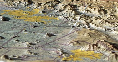
The 3-D Aeronautical Chart – Phoenix / Tucson is a moulded relief chart presenting the Arizona terrain from the Flagstaff and Mount Humphreys area south to Tucson. Its three-dimensional terrain representation is designed to help users visualise the relationship between terrain, airspace and flight planning information.

Suitable for flight-planning reference, training environments, offices, hangars and aviation displays.

  • Coverage: Phoenix–Tucson region, Arizona, including terrain from the Flagstaff/Mount Humphreys area to Tucson
  • Format: precisely moulded 3D terrain chart
  • Scale: 1:500,000
  • Approximate size: 76 cm high × 51 cm wide
  • Unit of measure: each

Roctexo part number: RX1-13-12430.

These products might also be of interest

Your Dynamic Snippet will be displayed here... This message is displayed because you did not provided both a filter and a template to use.